
What would I like to see for Adelaide's transport system? With our latest oil disocovery, maybe some coffers can be put into...
Upgrade of South Road to expressway standard, 6 lanes each way (requires property acquisition) in-grounded (less visual obtrusion) with access ramps from the median (to improve flow efficiency) at all major intersections, and crossover bridges for minor roads running directly across.
Extension of S. Exp to cross over Onkaparinga River Valley (earth cut & bridge) to re-adjoin Victor Harbor Road, which is duplicated to freeway standard, with bypass at Mount Compass and flows into the Ring Road on outskirts of Victor. S. Exp is widened 6 lanes from southern-most exit of Main South Rd to northernmost exit, road is given right of way to South Rd.
Northern Expressway to proceed as per normal - however road needs right of way from Port Wakefield Road to N. Exp, and Salisbury Highway interchange upgraded so that right of way is also given for P.R Exp. traffic to proceed onto Port Wakefield Road, upgraded to freeway standard 3x3 lanes, with at-grade access to major intersections. The P.R Exp. also needs upgrading to 3x3 lanes between South Rd and Pt. Wakefield Rd.
Southern Bypass, new freeway standard hills route between the S.E Freeway and S. Exp, 2x2 with at grade intersections where applicable. Would help deviate freight traffic to Noarlunga away from metro.
Modbury Freeway re-instated, with extension of P.R Exp. through old Dry Creek train corridor through State Sports Park to Hanson? Rd near Northgate. 2x2 freeway standard with at-grade intersections where applicable (I think only Main North Rd). This would help freight traffic from S.E freeway travelling via Portrush Rd to access the Port.
-------------------------------------------------------
Demolition of O-Bahn guided busway, to be replaced with heavy rail corridor. Would be serviced underground through North Terrace precient - and resume ground level taking place of Plane Tree Drive, with rail underpass beneath the Ring Road, to eliminate traffic congestion as result of level crossing.
Extension of Noarlunga rail corridor to Aldinga. Country services reinstated to Victor Harbor via old Woodcroft rail corridor, stationing at McLaren Vale and re-adjoins current alignment somewhere to Goolwa. Barossa Valley services resume from Gawler rail line.
The rail-line that passes through Virginia is used for metro services, and extended to proposed Buckland Park precient. Would be used as a peak-hour express service only, to minimise congestion because it is a freight line.
New Cross-City rail underground from Noarlunga/Belair interchange through Unley suburbs, to tunnel 50/100m due east of KWS where re-aligned at Adelaide Station. Cross-city rail services from Port-Noarlunga/TTP-Noarlunga/Port-Belair/TTP-Belair.
Construction of new deviant of Belair train corridor from Belair to Mitcham/Torrens Park (tunneled) to help travel times of freight services, not used for metro.
Tram lines laid down Prospect Road, Port Road, West Lakes Boulevard, The Parade, North Terrace East, Hutt St, Morphett & Pulteney streets, West Terrace, South Terrace, Grenfell/Currie streets, Wakefield/Grote streets and Sturt/Angas? streets, Bradman Drive, Unley & Goodwood Roads.
Roads & Rail


Re: Roads & Rail
I agree entirely with the freeway plan posted by Cruise Control. This is much like the plan I would've come up with, it is the plan that makes the most sense as those routes such as Cross Road and South Road currently carry a lot of freight traffic, and this would take a load off of existing routes along NH1 in the Adelaide metro area such as Portrush Road, Hampstead Road and Grand Junction Road. That plan would require numerous tunnels and elevated roadways around the place. I also think that the section between Glandore and Wingfield should be tolled by distance travelled.
-
Dave_The_Planner
- Gold-Member ;)
- Posts: 75
- Joined: Mon Sep 03, 2007 9:10 pm
Re: Roads & Rail
The freeway plan is exactly what is required.
Hopefully in the next ten years we'll start to see some action on this issue. It is already long over-due.
Hopefully in the next ten years we'll start to see some action on this issue. It is already long over-due.
Re: Roads & Rail
I would love to see the tramlines being extended to North Adelaide down O'Connell St, and maybe even to The Parade Norwood and Melbourne St.
I am already impressed with the extension to City West, but I think it would even better if it reaches the above mentioned places.
I am already impressed with the extension to City West, but I think it would even better if it reaches the above mentioned places.
Visit my website at http://www.edgarchieng.com for more photos of Adelaide and South Australia.
Re: Roads & Rail
My Idea for the southern expressway is to duplicate it and continue it running aside the Tonsley/Noarlunga line like the Mandurah rail line and Kwinana Freeway in Perth.
Of course property acquisition would have to take place.
All pie in the sky though.

Of course property acquisition would have to take place.
All pie in the sky though.
Re: Roads & Rail
south road between the outer harbour rail line and cross road:
Green lines denote underpasses.
Red line denotes tram overpass.

Green lines denote underpasses.
Red line denotes tram overpass.
Re: Roads & Rail
North of Outer harbour rail line and south of Port River Expressway.
Being a highly industrial area i see no need for underpasses.
Days road intersection would be closed.
Red lines denote overpasses.

Being a highly industrial area i see no need for underpasses.
Days road intersection would be closed.
Red lines denote overpasses.
Re: Roads & Rail
I don't think Days Road should be closed. Days Road is quite an important entry point for accessing Mansfield Park, instead I think building a flyover from South Road to Days Road southbound should replace the existing intersection. There is another intersection a few hundred metres further north that should be restricted to ban right turns into the side road during peak hours.
Currently the right turning bays take up a fair bit of room along South Road. I think that they should be removed from the whole length of South Road (except at the overpass and underpass sites that Cruise has marked), where U-turn bays similar to those at the Emerson overpass should be created.
Currently the right turning bays take up a fair bit of room along South Road. I think that they should be removed from the whole length of South Road (except at the overpass and underpass sites that Cruise has marked), where U-turn bays similar to those at the Emerson overpass should be created.
-
jimmy_2486

- Legendary Member!
- Posts: 639
- Joined: Wed Apr 18, 2007 9:28 pm
- Location: Glenelg-Marion Area
Re: Roads & Rail
No, otherwise we'd be bulking up the size of threads that are already bursting full of info, let alone visions on top of those which should be separate and in this forum anyway.
Re: Roads & Rail
Rail extension canned
Jai Bednall
18Dec07
THE long-awaited rail extension from Noarlunga Centre to Seaford has been shelved by the State Government.
A feasibility study into the extension, which began two and a half years ago, was released this week, recommending the project not be considered again until at least 2011.
The State Government deemed the extension too expensive and a lesser priority to other public transport needs across the state.
The announcement comes despite years of lobbying by the southern community for better public transport services in the region.
Details of the study show the project was predicted to cost between $175 million to $215 million.
A further $56 million would also be needed to buy 14 new railcars to service the extended line.
Transport Department CEO Jim Hallion said the project was not feasible at this stage.
``We've got a lot of demands for capital in the public transport sector at the moment,'' he said.
``In an ideal world you would be able to provide the services before the population arrived, but we've got many other projects where demand is already there.''
The report says the project will not be considered until:
Other high frequency and high speed rail services and other public transport priorities are approved;
The concrete re-sleepering of the Noarlunga line is completed in 2011, and;
The population increases in southern Adelaide.
Details of how much the population would need to grow by or what other public transport projects were higher priorities were not included.
Onkaparinga Mayor Lorraine Rosenberg said she was disappointed with the government's lack of commitment to the project and its unwillingness to consider it again until at least 2011.
``And even then once they finally commit to the project, it's going to be another 10 years until they actually complete it,'' she said.
``We need something three years from now not 20 years from now.
``At the very least we would've expected an announcement today where the government committed to the project... but we haven't even got that.''
Transport Minister Patrick Conlon was unavailable for an interview on Monday (December 17).
An emailed statement from his media advisor Matt Clemow said: ``the cost benefit figures just don't add up but we strongly believe they will in the future''.
``Not only are we retaining the rail corridor, we are also looking to acquire more land in an Aldinga corridor with a view to a longer extension.''

Re: Roads & Rail
Gasp, shock, horror. Didn't see that one coming. When will they get a clue about public transport?
Re: Roads & Rail
I've said it before and I'll say it again, I still think the State Government will release major plans to revamp the train network in next years State Budget.

Re: Roads & Rail
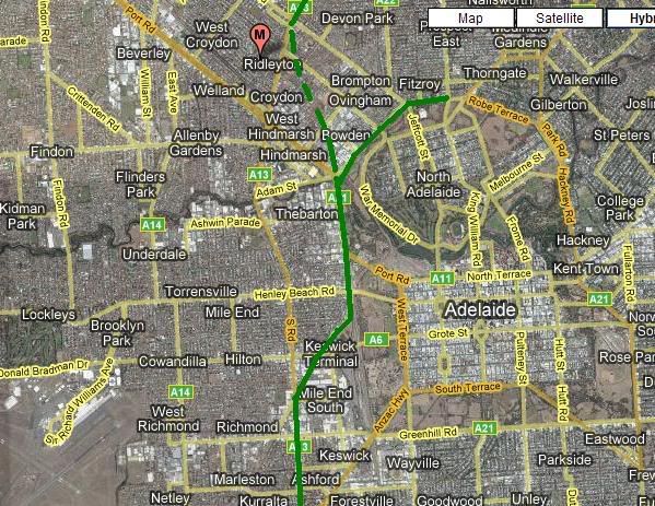
I think this is a better alignment for a north South Freeway. South Road bypasses the CBD and requires a lot of properties to be acquired. my idea is to go along south road untill it gets to the new James Congdon road, the continue along the West parklands and over the bakewell bridge onto south road. The problem then though is getting back onto south road. A tunnel could be build all the way from Port Road back to South Road. Park Terrace and Fitzroy Terrace could also be upgraded allowing acces to the freeway from the North East.
Im dead serious
Who is online
Users browsing this forum: No registered users and 7 guests