Ad blocker detected: Our website is made possible by displaying online advertisements to our visitors. Please consider supporting us by disabling your ad blocker on our website.
Threads relating to transport, water, etc. within the CBD and Metropolitan area.
-
rev
- SA MVP (Most Valued Poster 4000+)
- Posts: 6038
- Joined: Sat Nov 11, 2006 12:14 pm
#1606
Post
by rev » Thu Feb 18, 2016 2:17 pm
how good is he wrote:I think both sides of Pym St need to be closed off altogether or have no traffic lights with turn left only. How can a piddly intersection with negligible use be allowed to remain as a possible bottleneck in a $896m project??
Surely there needs to be a clear freeway to Regency Road (which needs to be addressed also eventually).
Also the rail bridge coming down at ground level instead of over Elizabeth/Queen St (for a minor increased cost) is a mistake. Even though a vocal community may have wanted it, future generations will regret the unnecessary congestion and delays caused.
The situation will only be temporary, as the section between the Super Way and T2T will also be upgraded in time.
The situation could be eased in the mean time by changing the light sequence.
The lights on south road stay green, until a vehicle pulls up at the Pym street lights.
Pym street lights only stay green for a very very short time anyway. It's hardly going to cause a bottle neck anymore then the small inconvenience it already does.
Besides until that section is completed, those sets of traffic lights along that small stretch are a good way to ensure that traffic slows down to 60 until they get to the superway.
-
alexczarn
- Gold-Member ;)
- Posts: 91
- Joined: Tue Nov 26, 2013 11:13 am
#1607
Post
by alexczarn » Thu Feb 18, 2016 11:31 pm
Why right turns onto Port Road are being forced to become u-turns, I can not fathom..
-
Hooligan
- Legendary Member!
- Posts: 887
- Joined: Tue Jul 28, 2009 8:03 pm
#1608
Post
by Hooligan » Fri Feb 19, 2016 7:02 am
alexczarn wrote:Why right turns onto Port Road are being forced to become u-turns, I can not fathom..
So right turning traffic doesn't bank up on the off ramp i would assume?
-
Llessur2002
- Super Size Scraper Poster!
- Posts: 2073
- Joined: Mon Mar 17, 2014 4:59 pm
- Location: Inner West
#1609
Post
by Llessur2002 » Fri Feb 19, 2016 8:55 am
alexczarn wrote:Why right turns onto Port Road are being forced to become u-turns, I can not fathom..
According to the Project Assessment Report:
The PAR introduced the removal of right turns from South Road onto Port Road to reduce delays. Drivers intending to make these turns will instead be catered for by redirection to signalised U-turn facilities on Port Road (Figure 3.12).
Traffic modelling shows that, of the total estimated 80,000 vehicles per day that use this intersection, fewer than 3% currently turn right from South Road onto Port Road. This, along with the current intersection arrangement, can lead to lengthy delays for drivers making this turn. Traffic models estimate that two-thirds of the north–south traffic on South Road will use the lowered road and travel under the Port Road intersection. Even at this much reduced traffic volume on the at-grade South Road/Port Road intersection, fewer than 3% of traffic would be turning right (if permitted).
Travel times for drivers currently making these turns has been measured and compared with the travel times modelled for the same movement via the U-turns on project completion (Table 3.1). This comparison clearly shows that although they travel slightly further, the trip is faster around the U-turn than the current right turn.
In addition, congestion and queues formed during train movements through level crossings make current travel times highly variable. On project completion, with most north–south traffic using the non-stop section of roadway, lower and more uniform travel times are expected.
The removal of the right turns from the intersection, along with design modifications that reduce the width of the Port Road median, will save substantial travel time for drivers. More green time in the traffic signal sequence will be allowed for other more significant movements. On completion of the project at the end of 2018, the average delay for drivers using this intersection during peak periods is expected to be approximately 20 seconds less than an intersection layout that includes these right turns. This reduction is predicted to become more than one and a half minutes by 2031.
The removal of the South Road/Port Road right turns also brings project savings with a simplified bridge design at Port Road. DPTI is continuing to work with the T2T Alliance to optimise the design of the Port Road/South Road intersection. The proposal to bypass the electrical substation is not related to removing these right turns. The refined concept design shows that shifting the alignment to the east reduces the level of risk to the project’s delivery. It is estimated that construction time will be reduced by one year, therefore lowering local community impact.
A number of responses to the PAR from members of the public did specifically comment on removal of the right turns. The Royal Automobile Association (RAA) of South Australia, the principal advocate for road users in South Australia on a broad range of motoring-related issues, supported the proposal. The RAA acknowledged that the removal of the right turns would be counter-intuitive to many, but would provide a positive safety benefit and reduce delays.
Drivers will still be able to turn right from Port Road onto South Road.
Restricting right turn movements in this way, when viable alternatives exist or can be created, is being considered for other signalised intersections across the Adelaide metropolitan network. This is an effective way to keep traffic moving in Adelaide and help to drive the South Australian economy, by making the best use of existing road infrastructure within the constraints of limited funding available in the current climate.
-
alexczarn
- Gold-Member ;)
- Posts: 91
- Joined: Tue Nov 26, 2013 11:13 am
#1610
Post
by alexczarn » Fri Feb 19, 2016 10:36 am
Cheers for the explanation mate.
-
drsmith
- Legendary Member!
- Posts: 513
- Joined: Wed Nov 07, 2007 3:35 pm
- Location: Perth
#1611
Post
by drsmith » Fri Feb 19, 2016 12:27 pm
Infrastructure Australia propriety list.
http://infrastructureaustralia.gov.au/p ... y_List.pdf
The remaining sections of the north-south corridor is identified as a near term priority (0 to 5 years - page 52). As good as that sounds, there's no way construction will be underway on all the remaining sections in that timeframe.
A Sturt Highway bypass of Truro is a medium term propriety (5 to 10 years - page 82) but a bypass of Port Wakefield as a specific project isn't on the list (>15 years). That though may be identified as subset of the National Freight and Supply Chain Strategy (page 35).
-
Waewick
- Super Size Scraper Poster!
- Posts: 3620
- Joined: Tue Jun 10, 2008 1:39 pm
#1612
Post
by Waewick » Fri Feb 19, 2016 4:10 pm
drsmith wrote:Infrastructure Australia propriety list.
http://infrastructureaustralia.gov.au/p ... y_List.pdf
The remaining sections of the north-south corridor is identified as a near term priority (0 to 5 years - page 52). As good as that sounds, there's no way construction will be underway on all the remaining sections in that timeframe.
A Sturt Highway bypass of Truro is a medium term propriety (5 to 10 years - page 82) but a bypass of Port Wakefield as a specific project isn't on the list (>15 years). That though may be identified as subset of the National Freight and Supply Chain Strategy (page 35).
I would love to see what the Truro bypass would look like
that part of the Sturt Highway is horrible.
-
mawsonguy
- High Rise Poster!
- Posts: 196
- Joined: Fri Dec 20, 2013 8:11 am
#1613
Post
by mawsonguy » Sat Feb 20, 2016 8:43 am
I haven't seen any consideration being given to the impact upon traffic in the Thebarton/Hindmarsh area once the T2T is completed.
At the moment, traffic travelling south on South Road that wishes to access the eastern side of the CBD turns left onto Torrens Road, Port Road or Manton Street. After T2T has bewen completed, that traffic will probably want to take the T2T to its southern end and then try to access the CBD by turning left down Adam Street, West Thebarton Road, George Street or Henley Beach Road. Adam Street, West Thebarton Road and Geogre Street aren't big enough to handle the traffic. The left turn filter lane at Henley Beach Road isn't long enough and traffic will proably bank up in the left lane on South Road. There is no left turn filter lane at West Thebarton Road (despite the millions they just spent upgrading the intersection) so traffic may bank up there as well. I predict major traffic congection at those 4 junctions/intersections once T2T is opened. IThe congestion will reduce after a while as drivers learn what works and what doesn't but it is still going to be a problem especially as traffic on South Road is likely to increase once T2T is completed when people who currently use Torrens Road, Churchill Road and Main North Road decide to use the expressway/connector/superway/motorway etc.
-
drsmith
- Legendary Member!
- Posts: 513
- Joined: Wed Nov 07, 2007 3:35 pm
- Location: Perth
#1614
Post
by drsmith » Sat Feb 20, 2016 12:42 pm
mawsonguy wrote:I haven't seen any consideration being given to the impact upon traffic in the Thebarton/Hindmarsh area once the T2T is completed.
http://www.infrastructure.sa.gov.au/__d ... rategy.pdf
From page 132 with particular references to R3, R4 and R5.
R3 and R4 are the areas to which you refer. R4 and R5 are the highest priority sections but are also the most costly. I suspect R4 will most likely be the next section to be funded so I'd imagine this is where there's the greatest reluctance to spend on interim upgrades. R3 is a lower priority and as such will probably be done later hence the Ashwin Parade/W Thebarton Road intersection is a better value upgrade on that aspect than at Henley Beach Road.
Who knows though how the ultimate construction schedule will pan out. Politically, it wouldn't surprise me if to some extent lower priority/lower cost sections get the nod ahead of some of the higher cost sections to maintain an ongoing construction program at minimum cost.
Port Road access strikes me as the best access to the CBD coming from the north on that section of South Road once T2T is complete. I've wondered about the viability of extending the tram line down the Port Road median to South Road as a PT option into the CBD but the parking that would have to be provided may be a difficulty with that option.
-
claybro
- Super Size Scraper Poster!
- Posts: 2378
- Joined: Mon Jun 18, 2012 9:16 pm
#1615
Post
by claybro » Sat Feb 20, 2016 2:06 pm
With regard to CBD access, one of the benefits of the South Road corridor is that it is less likely to become a CBD commuter freeway. This route is far enough away to discourage use by CBD workers, unlike the Perth experience which delivers commuters right to the edge of the CBD and creates peak hour gridlock having a knock on effect to the rest of the freeway network. This route has really happened by an accident of history(the least disruptive and cheapest route left) and probably the only option for connecting most industrial areas in one route. Commuter freeways should be avoided particularly to the CBD where public transport is the best option
-
muzzamo
- Legendary Member!
- Posts: 1026
- Joined: Tue Aug 21, 2007 4:44 pm
#1616
Post
by muzzamo » Sat Feb 20, 2016 5:52 pm
claybro wrote:With regard to CBD access, one of the benefits of the South Road corridor is that it is less likely to become a CBD commuter freeway. This route is far enough away to discourage use by CBD workers, unlike the Perth experience which delivers commuters right to the edge of the CBD and creates peak hour gridlock having a knock on effect to the rest of the freeway network. This route has really happened by an accident of history(the least disruptive and cheapest route left) and probably the only option for connecting most industrial areas in one route. Commuter freeways should be avoided particularly to the CBD where public transport is the best option
I have to disagree here - South Road will definately be a commuter freeway for those coming from the southern suburbs - it will be the fastest way to get into the city by far for at least a third (maybe a half?) of the residents of greater Adelaide.
The only solution here is congestion/network charging.
-
mawsonguy
- High Rise Poster!
- Posts: 196
- Joined: Fri Dec 20, 2013 8:11 am
#1617
Post
by mawsonguy » Sat Feb 20, 2016 6:25 pm
drsmith wrote:R4 and R5 are the highest priority sections but are also the most costly. I suspect R4 will most likely be the next section to be funded so I'd imagine this is where there's the greatest reluctance to spend on interim upgrades. R3 is a lower priority and as such will probably be done later hence the Ashwin Parade/W Thebarton Road intersection is a better value upgrade on that aspect than at Henley Beach Road.
R3 (south of Grange Rd to south of Ashwin Pde) is rated "medium-high". It has a low problem severity rating but a high strategic importance rating (p135). Put in plain English, the traffic moves reasonably well on this section so you don't save travel time by upgrading to a freeway but it's stupid to have 2 sections of freeway separated by a short non-freeway section. There is a real risk of the freeway being closed due to collisions that occur when cars have to decelerate from 90 to 60 especially if someone is half asleep and has forgotten that there is a short lower speed section. There is also the ripple effect that causes traffic jams. Just look at the west bound carriageway on Salisbury Hwy before it joins Port Wakefield Rd at about 4:00pm on a week day or the opposite side at 8:00am. Traffic drops to 60kph or lower until you are past the "blockage" only to find that there is no blockage. For this readson, and the reasons identified by "Dr Smith", I think R3 is likely to be done before R4.
However, there will be a problem with "rat runs" through Hindmarsh and Thebarton before then which can be alleviated with minimum work. Putting in roundabouts or speed humps on George Street and West Thebarton Road; changing traffic light sequences at Manton Tce and Adam St for example.
-
ChillyPhilly
- Super Size Scraper Poster!
- Posts: 2588
- Joined: Sun Dec 07, 2008 11:35 pm
- Location: Kaurna Land.
-
Contact:
#1618
Post
by ChillyPhilly » Sun Feb 21, 2016 2:08 am
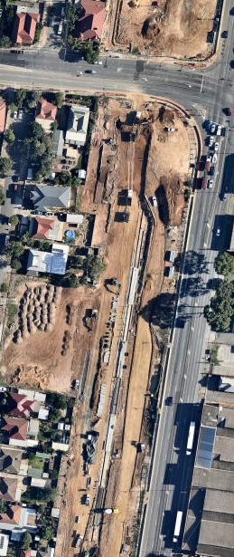
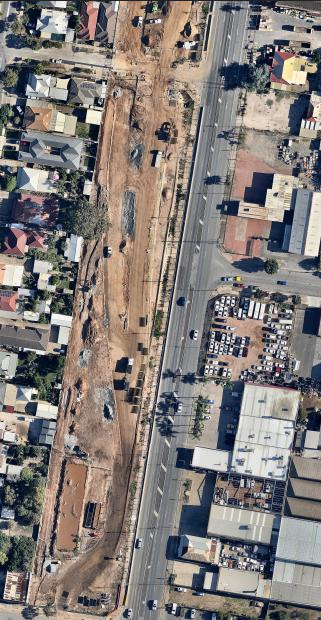
The latest from Nearmap. Imagery date: 6 February.
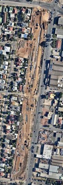
Zoomed in a little more, around the Grange Road intersection:
To the south of the above:
Our state, our city, our future.
All views expressed on this forum are my own.
-
mawsonguy
- High Rise Poster!
- Posts: 196
- Joined: Fri Dec 20, 2013 8:11 am
#1619
Post
by mawsonguy » Tue Feb 23, 2016 2:02 pm
The satellite photographs as at 9 Feb 2016 clearly shows a reinforced concrete "strip" being built between the northbound surface road and where the lowered roadway will eventually be constructed. A photograph in the latest Construction Newsletter has a photo showing this construction as "Top of the wall barrier". Not being an engineer, I just wonder how you can buid the top of a wall without first building the bottom of the wall! I thought it may be a barrier wall set back from the cutting retaining wall but the visualisations don't show that rather they show one continuous wall from the bottom of the cutting to the top of the barrier. I also thought it might be the gutter but the satellite photo shows capping not a gutter. Anyone with better knowledge of what is actually going on?
-
AG
- VIP Member

- Posts: 2073
- Joined: Thu Jul 21, 2005 9:44 am
- Location: Adelaide SA
#1620
Post
by AG » Wed Feb 24, 2016 6:53 am
mawsonguy wrote:The satellite photographs as at 9 Feb 2016 clearly shows a reinforced concrete "strip" being built between the northbound surface road and where the lowered roadway will eventually be constructed. A photograph in the latest Construction Newsletter has a photo showing this construction as "Top of the wall barrier". Not being an engineer, I just wonder how you can buid the top of a wall without first building the bottom of the wall! I thought it may be a barrier wall set back from the cutting retaining wall but the visualisations don't show that rather they show one continuous wall from the bottom of the cutting to the top of the barrier. I also thought it might be the gutter but the satellite photo shows capping not a gutter. Anyone with better knowledge of what is actually going on?
Top-down construction happens all the time on building and infrastructure sites! The trick is holding back the excavation while going deeper as the lateral forces are held back by less and less resistance. There's no less than three different types of top-down shoring/retaining methodologies.
Without seeing any photos and going purely off what you've described, I think they've either driven a series of reinforced concrete piles into the ground and then constructed a pile capping across all of them, or they've excavated a vertical trench and filled it with slurry and the reinforcing steel cage prior to backfilling with concrete to create the wall - more likely the latter.
Who is online
Users browsing this forum: No registered users and 41 guests