
[COM] M2 Northern Connector | 15.5km | $867m
[COM] Re: PRO: Northern Connector | 14km | $1b
Surely, something like this would be more practical? Passes over the rail line at a narrow point, utilises under-developed industrial land, does not disrupt existing roads and keeps the turns wide.
-
ChillyPhilly
- Super Size Scraper Poster!
- Posts: 2588
- Joined: Sun Dec 07, 2008 11:35 pm
- Location: Kaurna Land.
- Contact:
[COM] Re: PRO: Northern Connector | 14km | $1b
That's basically the original MATS corridor.
Our state, our city, our future.
All views expressed on this forum are my own.
All views expressed on this forum are my own.

[COM] Re: PRO: Northern Connector | 14km | $1b
The earth has started to move according to the following announcement from earlier this month,
IIRC, material placed over the salt pans had to be allowed to settle for a year before road works proper could begin in that area.
http://paulfletcher.com.au/media-centre ... -jobs.htmlTwo Aboriginal companies have been awarded contracts for work on North-South Corridor projects providing job opportunities for dozens of Aboriginal employees.
Federal Minister for Major Projects Paul Fletcher said Intract Australia - Indigenous contractors - had begun preliminary earth carting works on the $985 million dollar Northern Connector project.
“The Turnbull Government is pleased to be contributing $788 million towards this project which is one of the first to contract out work under the Commonwealth Indigenous Procurement Policy,” Mr Fletcher said.
“Five members of the 10-strong workforce employed by Intract Australia to complete this earth carting work are Aboriginal people.
“The works include delivering up to 1000 tonnes of fill and brine mud each day to fill in embankments across the salt pans up to four metres high before major construction starts in May.”
IIRC, material placed over the salt pans had to be allowed to settle for a year before road works proper could begin in that area.
[COM] Re: PRO: Northern Connector | 14km | $1b
The Northern Connector project map has been updated.
http://www.infrastructure.sa.gov.au/__d ... t-plan.pdf
At the northern end, the northbound carriageway connection to the Northern Expressway is returned to the northernmost gap under the PWR bridge. This presumably is a (long term) temporary alignment prior to the rail line construction.
The bike path is either nest to or the shoulder of PWR between the Northern Expressway and Waterloo Corner Road.
There's a roundabout connection between Kings Road and Bolivar Road east of PWR.
At the southern end, the tie-in into Salisbury Highway is 3 lanes in each direction.
[COM] Re: PRO: Northern Connector | 14km | $1b
The shared path must be next to PWR, not on the shoulder itself, as riding northbound would not work on the shoulder of the southbound carriageway. I have not been game to try it in the current configuration, riding on the shoulder next to road trains! It will be interesting to see if they remember to put bike lights and large enough space by the two sets of traffic lights at WCR for groups of cyclists and walkers/runners to cross in both directions without spilling into the roads.drsmith wrote:The bike path is either nest to or the shoulder of PWR between the Northern Expressway and Waterloo Corner Road.
The map has shown that layout for a month or so. some of the property boundaries are quite close to the current carriageway, so there would need to be either a safety fence or some realignment required to make this version of the plan safe for young riders. It was interesting to accompany a friend with his three-year-old on part of the Stuart O'Grady Bikeway recently. It felt like a very safe place for a child to learn to ride in a straight line, and feel like he had gone somewhere. We could not have done this if he could have accidentally drifted onto the road, since following Dad's instructions comes second to enjoying what he is doing.
[COM] Re: PRO: Northern Connector | 14km | $1b
The configuration I was thinking where the pink line was on a road carriageway was northbound on the northbound shoulder and southbound on the southbound shoulder or essentially as is.SBD wrote:The shared path must be next to PWR, not on the shoulder itself, as riding northbound would not work on the shoulder of the southbound carriageway. I have not been game to try it in the current configuration, riding on the shoulder next to road trains! It will be interesting to see if they remember to put bike lights and large enough space by the two sets of traffic lights at WCR for groups of cyclists and walkers/runners to cross in both directions without spilling into the roads.drsmith wrote:The bike path is either nest to or the shoulder of PWR between the Northern Expressway and Waterloo Corner Road.
The map has shown that layout for a month or so. some of the property boundaries are quite close to the current carriageway, so there would need to be either a safety fence or some realignment required to make this version of the plan safe for young riders. It was interesting to accompany a friend with his three-year-old on part of the Stuart O'Grady Bikeway recently. It felt like a very safe place for a child to learn to ride in a straight line, and feel like he had gone somewhere. We could not have done this if he could have accidentally drifted onto the road, since following Dad's instructions comes second to enjoying what he is doing.
I don't think that will fly and there's no indication of a crossing point for northbound at the local road access immediately south of the present PWR bridge over the Northern Expressway.
There's also no hint in the map of work for the carriageway you suggest may be realigned (not highlighted). It may be as you suggest but without the need to move the southbound carriageway.
[COM] Re: PRO: Northern Connector | 14km | $1b
I was riding my bike along Little Para River tonight and observed a large amount of earhworks going on between the river and the SA Water Waste Treatment plant. Too far south for the Bolivar Interchange but appears to be on the Northern Connector alignment.
-
ChillyPhilly
- Super Size Scraper Poster!
- Posts: 2588
- Joined: Sun Dec 07, 2008 11:35 pm
- Location: Kaurna Land.
- Contact:
[COM] Re: PRO: Northern Connector | 14km | $1b
There's minor work going on around the southern vicinity of the salt pans. Can be seen from a relative distance. Excavator in sight.
Our state, our city, our future.
All views expressed on this forum are my own.
All views expressed on this forum are my own.

[COM] Re: PRO: Northern Connector | 14km | $1b
Hopefully the next project will be connecting east-west to the north-south roads.monotonehell wrote:The immediate north of Adelaide area has always suffered from a lack of east-west A roads. Other than Grand Junction and Regency Roads, all others only go part of the way. Everything else is spoke-like from the CBD.
But given the lack of population growth in the east without major infill, I doubt it will happen.
[COM] Re: PRO: Northern Connector | 14km | $1b
If it's what I'm thinking of, that's been going on for ages well before any funding announcement for the northern connector.ChillyPhilly wrote:There's minor work going on around the southern vicinity of the salt pans. Can be seen from a relative distance. Excavator in sight.
[COM] Re: PRO: Northern Connector | 14km | $1b
They're harvesting the saltrev wrote:If it's what I'm thinking of, that's been going on for ages well before any funding announcement for the northern connector.ChillyPhilly wrote:There's minor work going on around the southern vicinity of the salt pans. Can be seen from a relative distance. Excavator in sight.
-
victorious80
- Gold-Member ;)
- Posts: 87
- Joined: Fri Jul 31, 2009 8:33 am
[COM] Re: PRO: Northern Connector | 14km | $1b
They are preloading the site with fill, to ascertain level of subsidence. This will then feed into the road structural design.
[COM] Re: PRO: Northern Connector | 14km | $1b
But the tender hasn't even been awarded yet?victorious80 wrote:They are preloading the site with fill, to ascertain level of subsidence. This will then feed into the road structural design.
-
victorious80
- Gold-Member ;)
- Posts: 87
- Joined: Fri Jul 31, 2009 8:33 am
[COM] Re: PRO: Northern Connector | 14km | $1b
DPTI is delivering the works outside of the main contract as preliminary works. Due to the time required to allow the fill to settle, they couldn't afford to wait until a head contractor was onboard. The same works needed to be done regardless of which tenderer won.
Additionally, DPTI is upgrading the Bolivar / Kings Rd intersection as preliminary works, outside the main contract. The works should be complete in a couple on months, before head contractor hits the site.
Additionally, DPTI is upgrading the Bolivar / Kings Rd intersection as preliminary works, outside the main contract. The works should be complete in a couple on months, before head contractor hits the site.
[COM] Re: PRO: Northern Connector | 14km | $1b
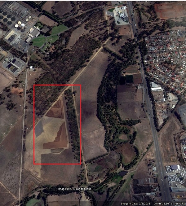
Below is a photo from Google Earth supposedly taken as at 3 March 2016 which shows a large amount of dirt being dumped to the West of Pt Wakefield Rd and to the North of Little Para River. I'm not sure if this is related to the Northern Connector.
Who is online
Users browsing this forum: Ahrefs [Bot] and 130 guests