Page 43 of 81
[COM] Re: Northern Connector | 14km | $1b
Posted: Sun Jan 07, 2018 5:41 pm
by drsmith
The big tease on the publication of the current design continues.
Interchange maps will be published early 2018 according to an update on the DPTI project page.
[COM] Re: Northern Connector | 14km | $1b
Posted: Sat Jan 13, 2018 10:05 pm
by mawsonguy
The Northern Connector needs a lot of dirt which is coming from T2T and the O-Bahn tunnel. The December newsletter for the T2T says that 83% of the trench has been excavated. Obviously, the O-Bahn tunnel has been completely excavated. But, at the moment, the road bed across the salt pans only goes half way and we need a lot more dirt at the interchanges. Even allowing for the stockpile near the Bolivar sewage works, I wonder if there is enough dirt to finish the project. If not, where is the extra going to come from?
[COM] Re: Northern Connector | 14km | $1b
Posted: Sat Jan 13, 2018 10:15 pm
by Goodsy
mawsonguy wrote: ↑Sat Jan 13, 2018 10:05 pm
The Northern Connector needs a lot of dirt which is coming from T2T and the O-Bahn tunnel. The December newsletter for the T2T says that 83% of the trench has been excavated. Obviously, the O-Bahn tunnel has been completely excavated. But, at the moment, the road bed across the salt pans only goes half way and we need a lot more dirt at the interchanges. Even allowing for the stockpile near the Bolivar sewage works, I wonder if there is enough dirt to finish the project. If not, where is the extra going to come from?
I'm sure they know what they're doing... Do you seriously think they just started excavating the roadway and now suddenly they need to think about where the materials are going to come from?
[COM] Re: Northern Connector | 14km | $1b
Posted: Sat Jan 13, 2018 10:25 pm
by mawsonguy
Goodsy wrote: ↑Sat Jan 13, 2018 10:15 pm
I'm sure they know what they're doing... Do you seriously think they just started excavating the roadway and now suddenly they need to think about where the materials are going to come from?
I'm sure they have a plan but I also know that they were not certain how much subsidence they would get on the roadway across the saltpans. I would hope that their plan included a contingency in case subsidnece was greater than forecast. I would also be surprised if the amount of dirt they needed just happened to exactly match the amount they were digging out of T2T and the O-Bahn tunnel.
[COM] Re: Northern Connector | 14km | $1b
Posted: Sat Jan 13, 2018 11:55 pm
by Mr Messy
Remember that they still need to dig out darlington
[COM] Re: Northern Connector | 14km | $1b
Posted: Sun Jan 14, 2018 8:50 pm
by mawsonguy
Mr Messy wrote: ↑Sat Jan 13, 2018 11:55 pm
Remember that they still need to dig out darlington
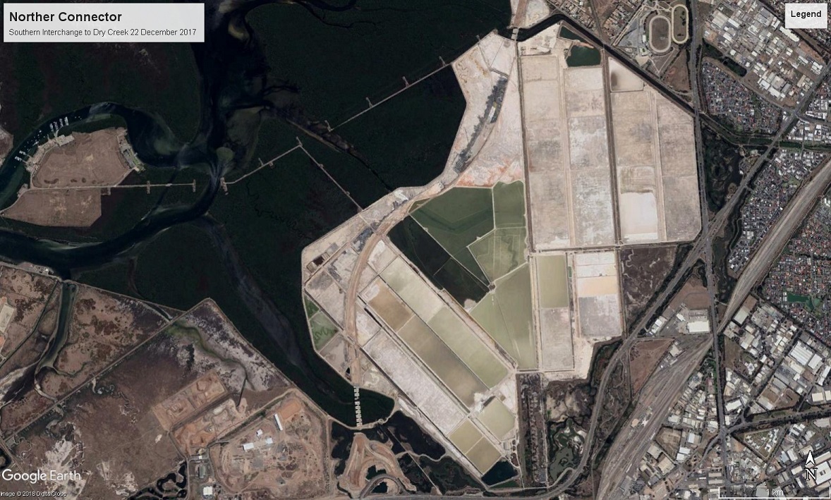
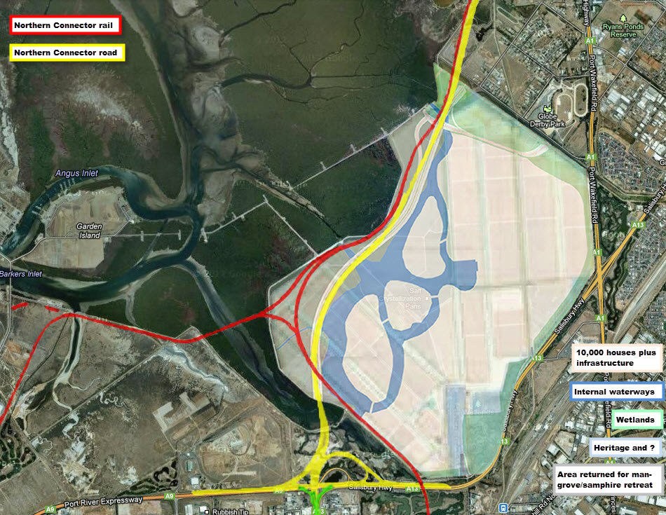
That's a long way to cart dirt for the NC.
The concept plans for the Dry Creek salt pans development showed lakes being excavated (see below). It would make more sense to take any shortfall from those areas.
[COM] Re: Northern Connector | 14km | $1b
Posted: Mon Jan 15, 2018 1:58 am
by rev
Forget housing, that should be turned into a new industrial area, with the aim of centralizing the majority of industrial sites scattered across the west/north westand turning those areas into housing. Areas such as Underdale around the river, beverly, thebarton, mile end south, royal park and even the stuff around the inner part of the harbor at Port Adelaide.
I mean whose gonna want to live next to the mangroves? The mosquito issue...its already bad enough at nearby Mawson Lakes...it'll be much worse there.
It's not like travel will be an issue to the salt pans...most of the areas I mentioned are on the north-south corridor route so will be linked directly, and the Port is linked by the PREXY to it..even that light industrial area at Pooraka is on the door step of the salt pans so wouldn't be that much further for employees.
I'm sure the government can create some incentives for land owners/business owners.
That, in the mid term would be a better outcome then continuing the sprawl(not that I'm against that).
But the state isn't flush with cash, and developers will expect some benefit if the government expects them to develop the infrastructure up north.
Create a new industrial zone, creating thousands of jobs to build within the metro footprint.
Old industrial sites then turned into housing developments, catering to demand, creating more or sustaining jobs in construction.
[COM] Re: Northern Connector | 14km | $1b
Posted: Mon Jan 15, 2018 2:09 am
by how good is he
While I hope I am wrong I can’t see much demand for industrial. Housing is the safest bet and higher sqm rate for the developers. There is also the potential for even higher return/a better use by creating waterfront canals/allotments aka Salt Lake City. You are right it’s near the Prexy etc and some 13km from the city and extends near Mawson Lakes.. so it’s a better alternative for a comparable price to say Buckland Pk etc..
[COM] Re: Northern Connector | 14km | $1b
Posted: Mon Jan 15, 2018 8:30 am
by mawsonguy
We appear to have gone off thread.
There is still plenty of vacant land and numerous unoccupied sites in the industrial corridor that stretches from Pooraka to Port Adelaide and up to Outer Harbour. There is also the underdeveloped industrial estate at Edinburgh. Adelaide does not need more industrial estates, what it needs is more industry.
[COM] Re: Northern Connector | 14km | $1b
Posted: Tue Jan 23, 2018 8:44 pm
by mawsonguy
[COM] Re: Northern Connector | 14km | $1b
Posted: Fri Feb 02, 2018 12:25 am
by ChillyPhilly
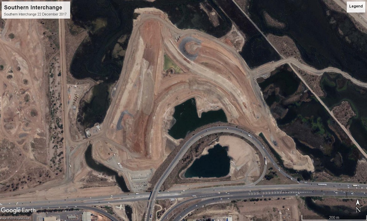
Basic update from observations of the southern interchange:
- Earthworks continue and are now starting to form recognisable shapes and paths of ramps.
- The existing bridge over PRExy is undergoing the beginning of demolition. The western side is being dismantled where the northwards extension of the Motorway will be located.
- Pylons to support this northwards extension are underway, with one row in place already and another row, closer to the PRExy roadway, currently being reinforced.
- The wetlands affected by ramp construction are slowly being drained over time.
[COM] Re: Northern Connector | 14km | $1b
Posted: Thu Feb 15, 2018 5:15 pm
by ChillyPhilly
Barriers now line virtually all of the southern PRExy carriageway between the Motorway and Hanson Road, where trees have also been removed.
[COM] Re: Northern Connector | 14km | $1b
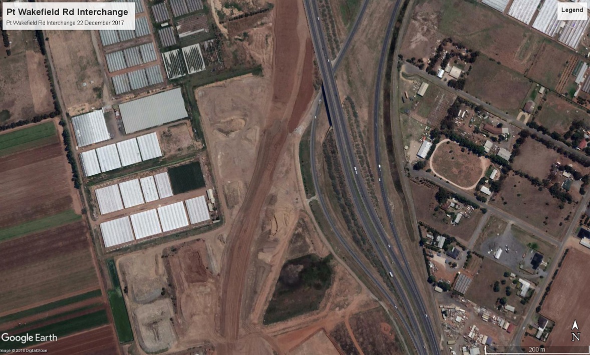
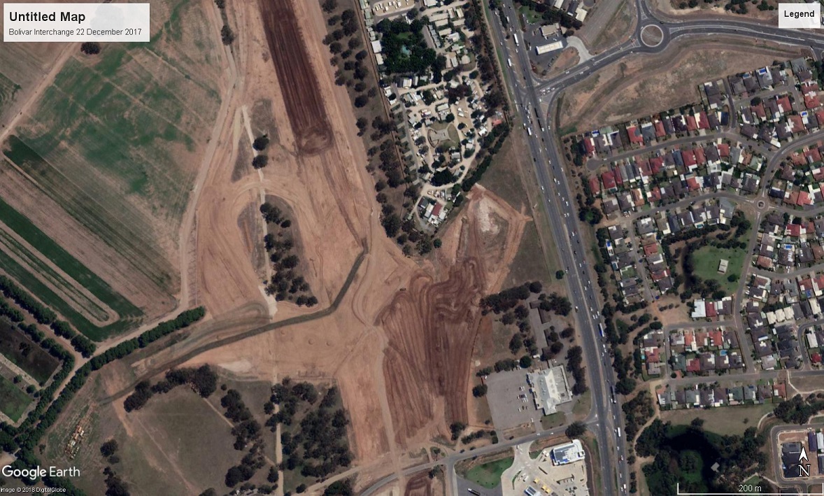
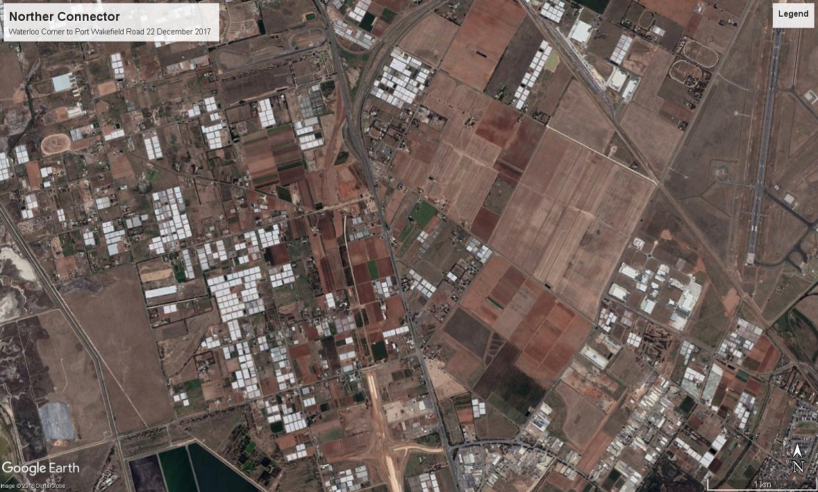
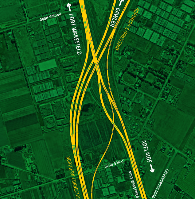
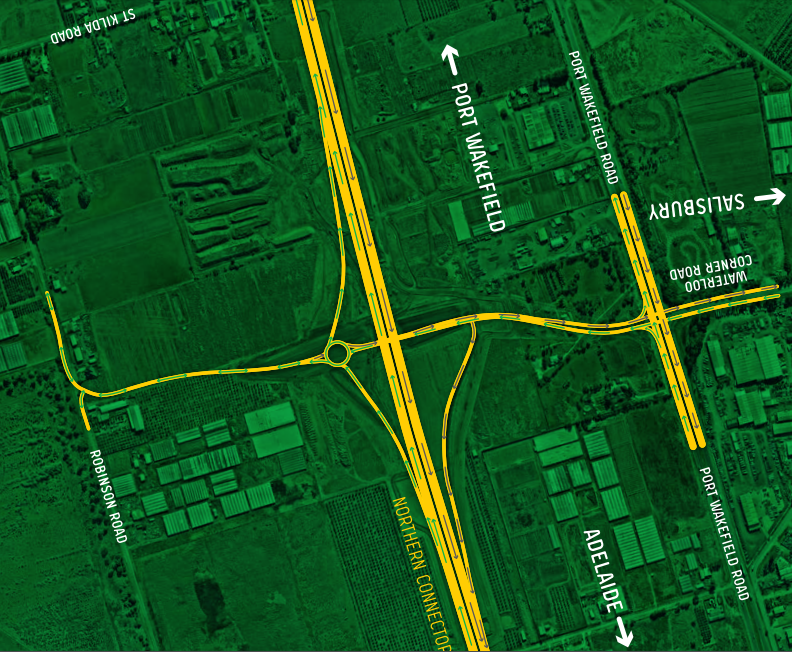
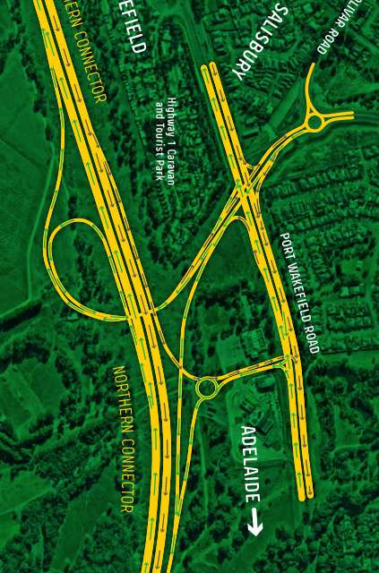
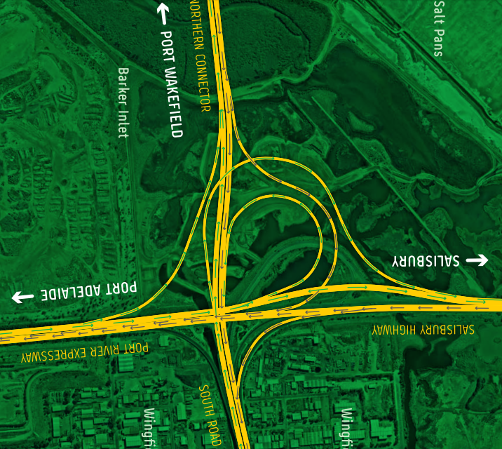
Posted: Wed Feb 28, 2018 11:43 am
by ChillyPhilly
As Mr Messy posted (
viewtopic.php?p=164096#p164096) in the South Road/N-S Corridor thread, final designs for the interchanges along the Northern Connector are up.
Here they are rotated and cropped.
[COM] Re: Northern Connector | 14km | $1b
Posted: Thu Mar 01, 2018 7:11 pm
by ralmin
I'm still waiting to see a detailed map of how the shared cycling pedestrian pathway will cross over or under the junction with Salisbury Hwy and Port River Expressway, to connect between South Road and the path that follows the Northern Connector.
At some point in the future I hope there is also an east-west pathway constructed, to get bikes off the Port River Expressway.
[COM] Re: Northern Connector | 14km | $1b
Posted: Thu Mar 01, 2018 10:29 pm
by SBD
ralmin wrote: ↑Thu Mar 01, 2018 7:11 pm
I'm still waiting to see a detailed map of how the shared cycling pedestrian pathway will cross over or under the junction with Salisbury Hwy and Port River Expressway, to connect between South Road and the path that follows the Northern Connector.
At some point in the future I hope there is also an east-west pathway constructed, to get bikes off the Port River Expressway.
The Cycle Instead website shows a path under Salisbury Highway in one of the drains just to the west of the Barker Inlet Wetlands parking bay. I don't know whether that is accessible at al tides to become the main route if it got sealed paths connected.